Civil Engineering Archive
Applications of GIS

Resource and geological exploration Location of engineering structures such as bridges, tunnels or dams can do by studying the satellite imageries. The siting of storage reservoirs can be studied. The study of alternative sites for the alignment
Geographic information system
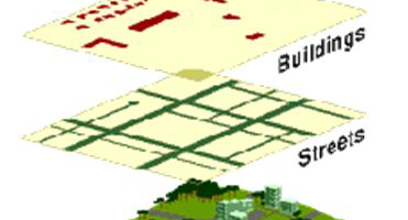
Geographic information system [GIS] is computer software which gives information of any discipline. It can be defined as an organized collection of computer hardware, software, geographic data and personally designed to efficiently capture, store, update, manipulate, analysis,
Application of GPS
Application to surveying Establishment of high precision zero order geodetic national survey control network of GPS station connecting Remote Island to mainland geodetic control networks. Survey control for topographical and cadastral surveys. Ground control for photogrammetric control
What is a global positioning system
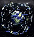
The global positioning system [GPS] is a navigation system used for determining one’s precise location and providing a highly accurate time reference almost anywhere on earth or in earth orbit. It is a fast and accurate method
What is electronic distance meter
In the direct measurement, the help of tape, the distance measurement can fully be obtained, but direct measurement sometimes becomes difficult when the terrain is rough or when the site is congested. In such case electronics distance
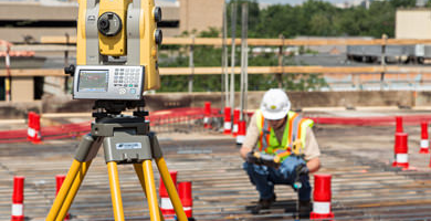
What is a total station?
When digital theodolite is fitted with electronic distance measuring units so that the distances and angles can be measured simultaneously they become total station these are operated using a multi-faction keyword which is connected to a microprocessor
Principals of surveying
Surveying involves different operation and techniques, but all these are based on the following principals such as: To work from whole to part Location of a point of measurement from two of reference. The work from whole
Working principle of E.D.M
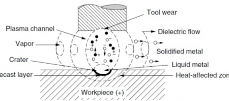
These operate on the principle that transmitter at the master station sends modulated continuous carrier wave to a receiver at the remote station from which it is returned. The instruments measure slope distance D between transmitter and
Applications of total station
To measure horizontal and vertical angles. To obtain the horizontal distance, inclined distance and vertical distance between these points. To get the three-dimensional co-ordinates i.e.[x,y,z] of a point in space. To find the length of a missing
Electronic distance meter (EDM)
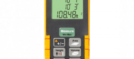
To measure horizontal distance, sloping distance and vertical distance between two points. To get the elevation of the remote object. To set the point at a predetermined distance along grid lined. To align the electronic plots or